Hiking in Slovenia » Slovene Istria » Slavnik » Slavnik and Grmada from Podgorje
The shortest routes to Slavnik lead from Podgorje, a small karst village south-west of the mountain. From this starting-point you can reach your goal by the Steep path (which deserves its name), the Gentle path (where you hardly even shed a drop of sweat) or an abundance of little paths and cart-tracks which ascend across the slopes of Slavnik.
At a glance
- Difficulty
- A clearly waymarked, gentle path
- Access
- Podgorje, 8 km from the main road Ljubljana-Koper.
- Distance
- Podgorje-Slavnik 1 hour 30 minutes
Return: 1 hour
Total: 3 hours - Altitude
- Slavnik: 1028 m
Grmada: 1001 m - Height difference
- Podgorje–Slavnik: 510 m
Including the visit to Grmada the ascent is almost 600 m. - Season
- You can visit Slavnik in any season. Since the path mostly runs through sparse forest, it is also good in mid-summer. I would only advise against it on windy days (the »bora« almost blew me off the summit), although precisely then you have the finest view.
- Equipment
- As always, good footwear will do no harm but for the easier path to Slavnik, no mountaineering equipment is necessary.
- Map
- Slovenska Istra, Čičarija, Brkini in Kras 1 : 50.000, PZS 1997
A map also awaits you at the start of the route.
From Podgorje to Slavnik
You set out for Slavnik from Podgorje, a village 8 km from the highway Ljubljana-Koper. You reach Podgorje most easily by leaving the motorway at the Kastelec exit (immediately after a tunnel, if you travel from the Ljubljana direction) and then follow the signs for Podgorje.
Immediately before the beginning of the village, you cross the railway line (beside the railway station), and shortly afterwards a sign for a carpark directs you right to a fine visitors' carpark, where you can also get a map of the locality showing the waymarked paths to Slavnik and Kojnik.
You will notice on this map that two paths lead to Slavnik from Podgorje, which means you can add variety to the trip – we will reach Slavnik by the easier path and descend by the steep one.
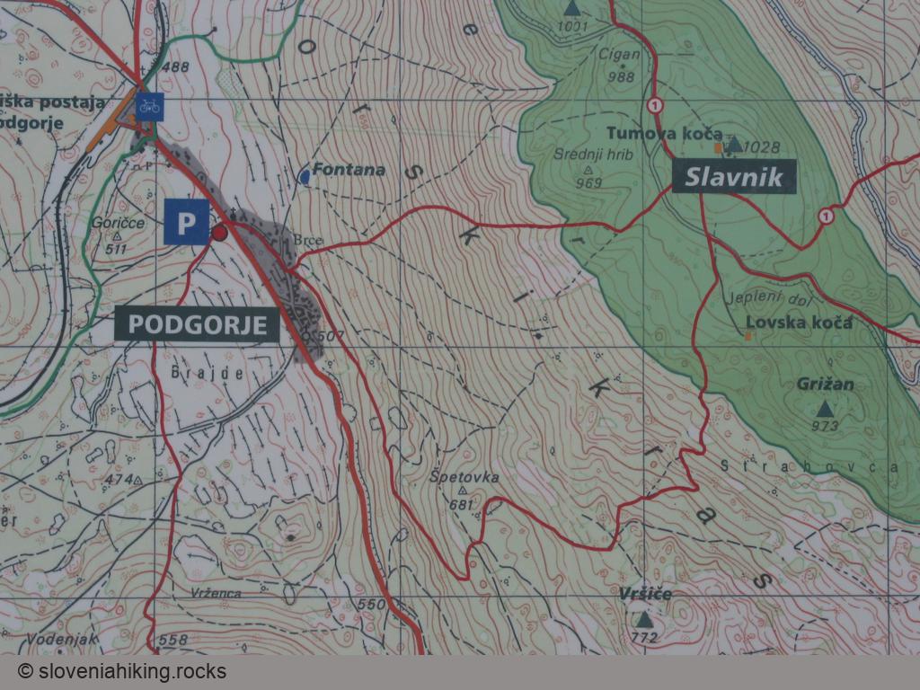
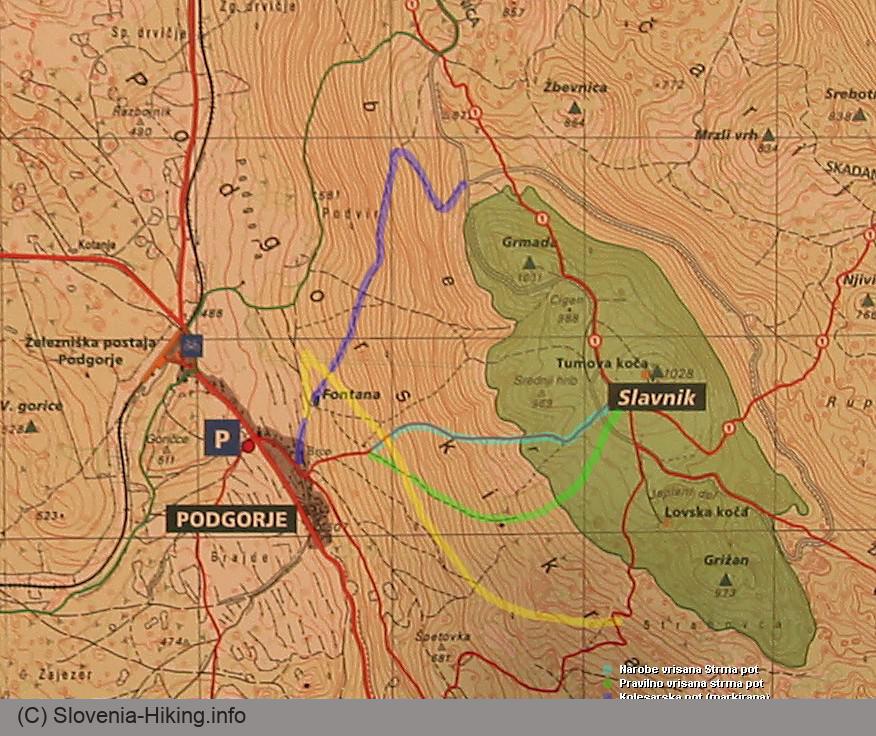
Ascent to Slavnik by the easier route
Return to the main road, turn left by the shrine into the village but then do not follow the first waymarks (which direct you to the steep path) but continue along the asphalt road until a signpost for the easier path points you left towards the hillside.
This path first runs through the forest almost parallel with the ridge and then slowly turns left to the hill between Špetovka and Vršiče. Here the forest thins, as the path passes alternately through copses, bushes and karst meadows. Such a varied environment is still favourable in autumn for the growth of many interesting wild flowers from cyclamen, knapweeds and pinks to campanulas and blue eryngo.
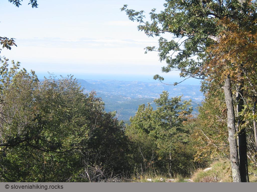
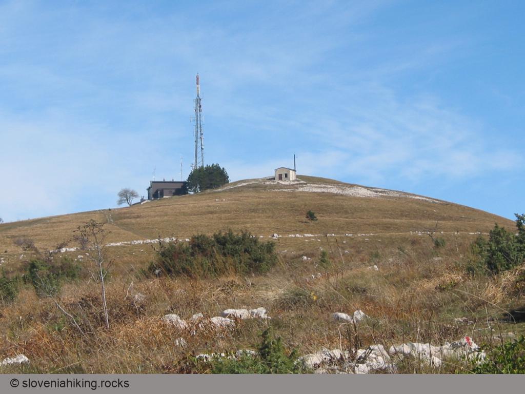
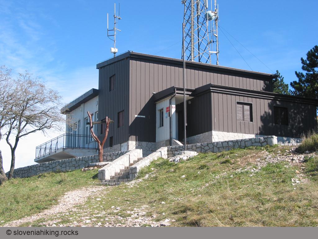
Towards the end of the ascent through the forest the first view of the Adriatic Sea opens up and soon afterwards you reach the karst meadows on the top of Slavnik. Here a protected region on the summit begins, and you also catch your first sight of the summit with the hut Tumova koča and a radio transmitter.
Slavnik
From the beginning of the karst meadows to Tumova koča you need a bare 15 minutes. In spring and summer these meadows are a veritable treasury of flowers, but in autumn they look considerably impoverished (especially because the floral abundance at the beginning of the path has really spoilt us); you will only find partly dried carline thistles and gentians.
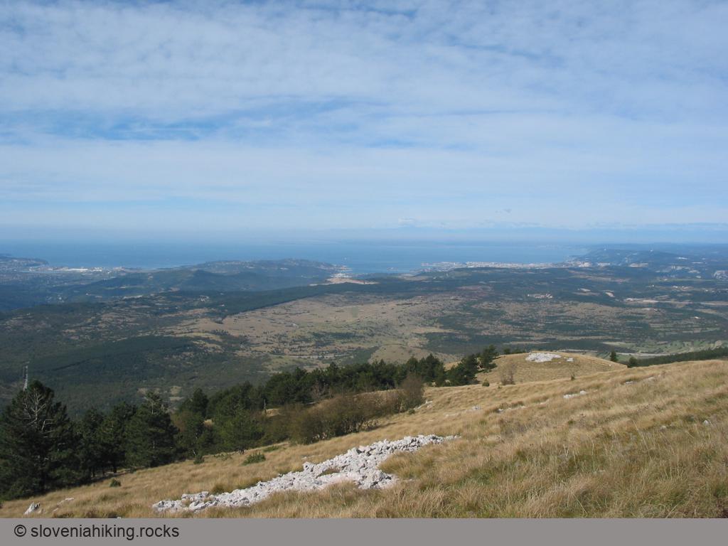
However, the disappointment over the flowers will be more than compensated for by the marvellous views – in front of the mountain hut the panorama opens up towards the south and west, while other parts of Slovenia are seen from the summit of Slavnik. Trnovski gozd with Nanos is also well seen and in really fine weather even the Slovene Alps.
After a short rest at Tumova koča allow yourself a good half-hour to make for the nearby summit of Grmada, from where you will have a still more beautiful view of the Slovene littoral (from Slavnik this is hidden precisely behind Grmada), but you can of course return to Podgorje – by the easier or the steep path.
Dropping by Grmada
Zealous mountaineers will aim for Grmada by the small path which leads straight over the top of Cigan (a slightly lower eminence between Slavnik and Grmada), those who conserve their energies will probably choose the slightly longer route along the macadam road towards Kozina. In both cases, you will end up at a junction where first the way to Hrpelje and then the way to Prešnica branch off, and finally the steep path to Grmada as well.
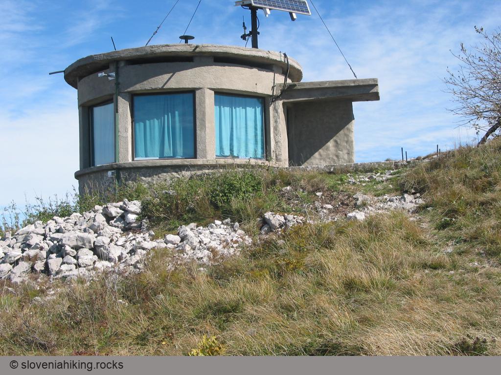
On top of Grmada you will find an interesting »tower«, which can be seen already from Slavnik. The local people say it was placed here after the Second World War as a lookout-point for forest fires, since Grmada offers the finest view of the surroundings, as you will see for yourself when you come panting to the top.
After your stop on Grmada you head back towards the summit of Slavnik and try to find the path by which you will return to Podgorje.
Going back to Podgorje by the steep path
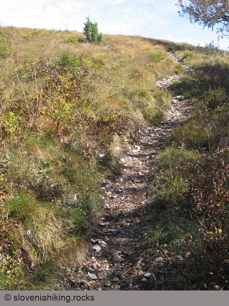
The return journey to Podgorje (or rather the search for the harder route) is the only more »entertaining« part of this trip. Since the top of Slavnik is completely grassy, there are practically no waymarks there (although of course it is possible to place waymarks even on such terrain – an excellent example is sv. Lovrenc above Postojna). Naturally at the weekend you'll have no problem for a throng of walkers come to Slavnik even by the steep path and you can easily observe where you must return, but if you're alone on the summit, the matter becomes rather more complex.
If you're going back to Podgorje from the top of Slavnik, try to »guess« where the path could go, but if you're returning from Grmada, walk along the macadam road and try to hit the correct turn-off to the right – the broad, well-used path should not be difficult to notice. The task is not too difficult (in the worst case you'll find yourself back on the easier path), but if impatience overcomes you, as it did with me, and you set off on the first path leading downhill, you'll walk along an unmarked path between Srednji hrib and Župnik known as »Žleb« (the gully).
If by chance you end up on this unmarked path (as I did), there's no need to panic or return to the summit – continue your way over the meadow, by the edge of the forest turn slightly left into the forest (this is essential; if you turn right, you will go too far to the west), and then drop down through the forest along a dry stream-bed and finally come onto a stone path which first bears to the right, then leads you straight downhill, crosses a macadam road until eventually a little before Podgorje it joins the waymarked path.
The appetite which you've worked up during the trip will certainly take you to the inn Pod Slavnikom in Podgorje (»fuži« with mushrooms (boletus) were so absolutely superb that they're impossible to forget), and then you can drive over the main road to visit Socerb on the Slovene-Italian border.